We’ve always had floods and bushfires, but climate change is making them worse
Queensland floods: Townsville reels under record water levels as more rain arrives, There are several more days to go in this 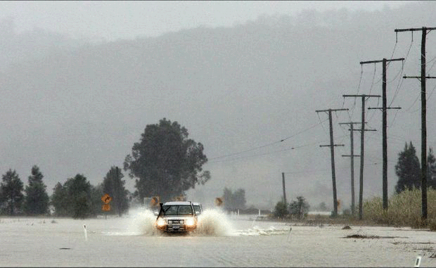 flood event, Bureau of Meteorology warns, Guardian, 2 Feb 2019,
Queensland authorities have said the state’s north was entering “unprecedented territory” as monsoon rains battered the city of Townsville, setting record flood levels and destroying homes.
Homes and businesses have been destroyed as flash floods washed through streets, sweeping away cars, equipment and livestock……..https://www.theguardian.com/australia-news/2019/feb/02/queensland-floods-townsville-reels-under-record-water-levels-as-more-rain-arrives
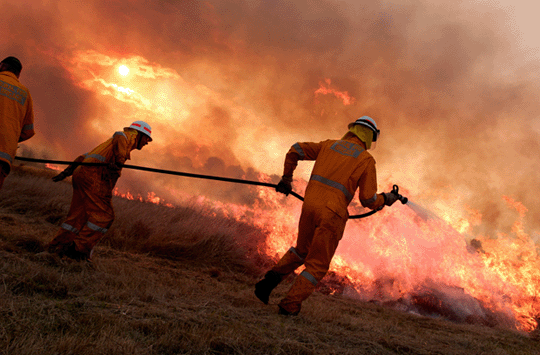
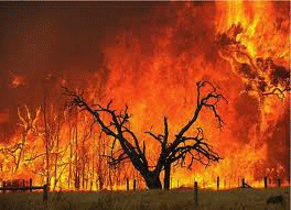 Bushfires threaten homes across Victoria , The Age, By Nicole Precel, 3 February 2019,Out-of-control bushfires threatened homes and lives on Sunday as more than 1000 firefighters battled major blazes across Victoria.Firefighters were stretched to the limit, fighting several large fires throughout the state.
A fire in Hepburn, in central Victoria was the major focus for the day with residents warned at daybreak to evacuate the town.
Two firefighters who were fighting the Hepburn fires were treated for heat exhaustion and over-exertion and were taken to hospital as a precaution.
Elsewhere, as almost 50 new fires sparked, emergency warnings were issued at various times for fires including days-old blazes in Timbarra in Gippsland and Grantville on the Bass Coast……..
As of Sunday afternoon, there were 69 aircraft working “very, very hard” and “effectively”.
The fires were fanned by soaring temperatures, hitting 43.3 degrees in the Mallee, 43.1 degrees in Hopetoun, 42.2 in Mildura, 41.1 at Melbourne Airport and 38.2 in Melbourne’s CBD.
The Bureau of Meteorology’s Richard Russell said high winds and thunderstorms were expected throughout the night……….. https://www.theage.com.au/national/victoria/bushfires-threaten-homes-across-victoria-20190203-p50vf8.html
 Tasmania’s fire disaster revealed in satellite images showing the extent of the damage
It’s easy to get warning fatigue, and, with only a handful or properties impacted so far, dismiss the fires as all bark and no bite.
But satellite images reveal the scale of the destruction so far.
The Gell River blaze, in the state’s south-west, was the first to start, ignited by a dry lightning strike in late December.
“It seems really like ancient history,” professor of pyrogeography and fire service at the University of Tasmania David Bowman said.
“It started at the end of last year and escalated in early January, so we’re looking at a fire situation that’s now gone for a full calendar month.”
Images taken by the European Space Agency’s Sentinel-2 satellite on January 3 show what seems, relative to the lakes around it, like a small blackened patch of wilderness……..
“There are multiple major fire events occurring simultaneously, which is extremely challenging for firefighters and fire managers because of the requirement to spread resources and make very difficult prioritising decisions.” …….
“This is definitely a historic event, it’s unprecedented,” Professor Bowman said.
“The area burnt is very substantial, I can barely keep up with the numbers.”
This week the fire service did put a number on it — 187,000 hectares.
At the same time as the Central Plateau fire ramped up, the Tahune fire was also burning out of control.
Of all the fires burning across Tasmania, this one has caused the most displacement, forcing hundreds of people to evacuate from communities in the Huon Valley south of Hobart.
Since last week, firefighters have issued almost daily warnings to residents, cautioning that only those prepared to defend their properties should stay behind.
A satellite image taken on January 30 shows how the fire, having burnt through more than 56,000 hectares, was still sending smoke over towns to its east. …..https://www.abc.net.au/news/2019-02-02/tasmanian-bushfires-from-the-air-satellite-images/10771528
No comments yet.
1 This month.

Australians deserve the truth
about
AUKUS – https://aukuspublicinquiry.com/
23 July – Australian Premiere: ‘Our Planet, The People, My Blood’ documentary
Thu, 23 Jul, 10am – 12pm ACST
The Mercury
13 Morphett St, Adelaide SA 5000
Link to register and more information here. tickets free but you must register
30 July – WEBINAR (Free) – Is Nuclear Power the Solution to Climate Change? https://my.acaw.org.au/event/acaw-is-nuclear-power-the-solution-to-climate-change
18:30 – 19:45 ACST
19:00 – 20:15 AEST

PETITION – To: Prime Minister Anthony Albanese and the Australian Labor Government

of the week – Australians for War Powers Reform (AWPR)
To see nuclear-related stories in greater depth and intensity

Leave a comment