Record warming coming to Eastern states because of sudden warming of air above Antarctica
The air above Antarctica is suddenly getting warmer – here’s what it means for Australia The Conversation Senior Principal Research Scientist, Australian Bureau of Meteorology, Manager of Long-range Forecast Services, Australian Bureau of Meteorology, Senior research scientist, Australian Bureau of Meteorology, Senior IT Officer, Australian Bureau of Meteorology, September 6, 2019
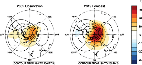
Record warm temperatures above Antarctica over the coming weeks are likely to bring above-average spring temperatures and below-average rainfall across large parts of New South Wales and southern Queensland.
In the coming weeks the warming is forecast to intensify, and its effects will extend downward to Earth’s surface, affecting much of eastern Australia over the coming months.
Although we have seen plenty of weak or moderate variations in the polar vortex over the past 60 years, the only other true sudden stratospheric warming event in the Southern Hemisphere was in September 2002.
What can Australia expect?
Impacts from this stratospheric warming are likely to reach Earth’s surface in the next month and possibly extend through to January.
Apart from warming the Antarctic region, the most notable effect will be a shift of the Southern Ocean westerly winds towards the Equator.
For regions directly in the path of the strongest westerlies, which includes western Tasmania, New Zealand’s South Island, and Patagonia in South America, this generally results in more storminess and rainfall, and colder temperatures.
But for subtropical Australia, which largely sits north of the main belt of westerlies, the shift results in reduced rainfall, clearer skies, and warmer temperatures.
Effects on the ozone hole and Antarctic sea ice
One positive note of sudden stratospheric warming is the reduction – or even absence altogether – of the spring Antarctic ozone hole. This is for two reasons.
First, the rapid rise of temperatures in the upper atmosphere means the super cold polar stratospheric ice clouds, which are vital for the chemical process that destroys ozone, may not even form.
Secondly, the disrupted winds carry more ozone-rich air from the tropics to the polar region, helping repair the ozone hole.
No comments yet.
1 This month.
Australians deserve the truth
about
AUKUS – https://aukuspublicinquiry.com/

30 July – WEBINAR (Free) – Is Nuclear Power the Solution to Climate Change? https://my.acaw.org.au/event/acaw-is-nuclear-power-the-solution-to-climate-change
18:30 – 19:45 ACST
19:00 – 20:15 AEST


PETITION – To: Prime Minister Anthony Albanese and the Australian Labor Government

of the week – Australians for War Powers Reform (AWPR)
To see nuclear-related stories in greater depth and intensity

Leave a comment